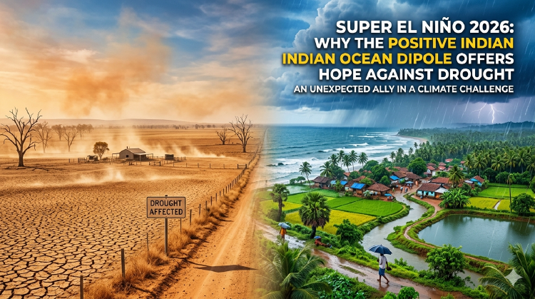
Super El Niño 2026: Why the Positive Indian Ocean Dipole Offers Hope Against Drought
Latest forecasts predict a Super El Niño event for 2026, but a concurrent positive Indian Ocean Dipole is expected to prevent the typical drought conditions over the Indian subcontinent.

- Dr. Vivek Shilimkar
- 5 min read
Introduction
Climate forecasters worldwide are closely monitoring oceanic conditions as multiple climate models indicate the development of what could be a “Super El Niño” event in 2026. Historically, such strong El Niño events have been associated with reduced monsoon rainfall over parts of the Indian subcontinent—typically 10-20% below normal—with regional variations in drought impacts. However, this time there’s a crucial difference: concurrent forecasts show a strong positive Indian Ocean Dipole (IOD) developing simultaneously, which could significantly buffer India against the typical El Niño-induced rainfall reductions.
What is a Super El Niño?
A Super El Niño represents the most extreme form of the El Niño Southern Oscillation (ENSO), characterized by sea surface temperatures in the central and eastern tropical Pacific rising 2.5°C or more above average. Only a handful of such events have been recorded in modern history, including the notable 1982-83, 1997-98, and 2015-16 events.
Key Characteristics of Super El Niño:
- Temperature Anomaly: Pacific Ocean temperatures exceeding +2.5°C above normal
- Geographic Extent: Warm water spread across a vast area of the Pacific
- Duration: Typically lasting 12-18 months
- Global Impact: Affects weather patterns worldwide, not just the Pacific region
Current Forecast Situation
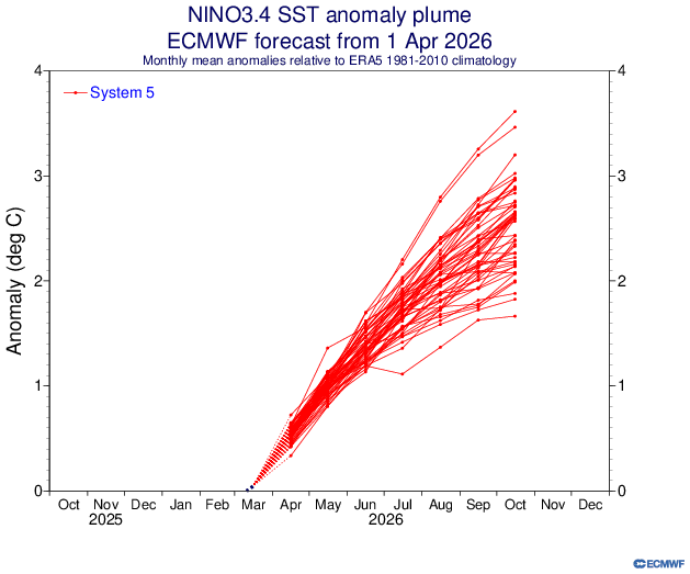
Latest climate models from major forecasting centers including NOAA, the Australian Bureau of Meteorology, and the European Centre for Medium-Range Weather Forecasts (ECMWF) are showing convergent signals:
El Niño Development
-
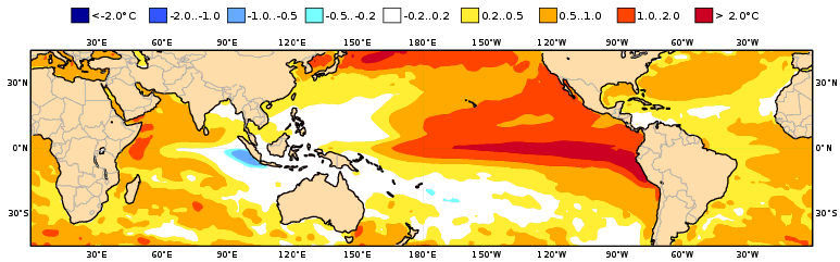
Strength: Models predict Niño 3.4 Index (NINO3.4) values reaching as high as +3°C by August 2026. (See the Pacific Ocean SST anomalies)
-
Timeline: El Nino is in developing phase right now, with rising intensity expected throughut the year.
-
Persistence: The event is forecast to continue through mid-2027
Indian Ocean Dipole Forecast
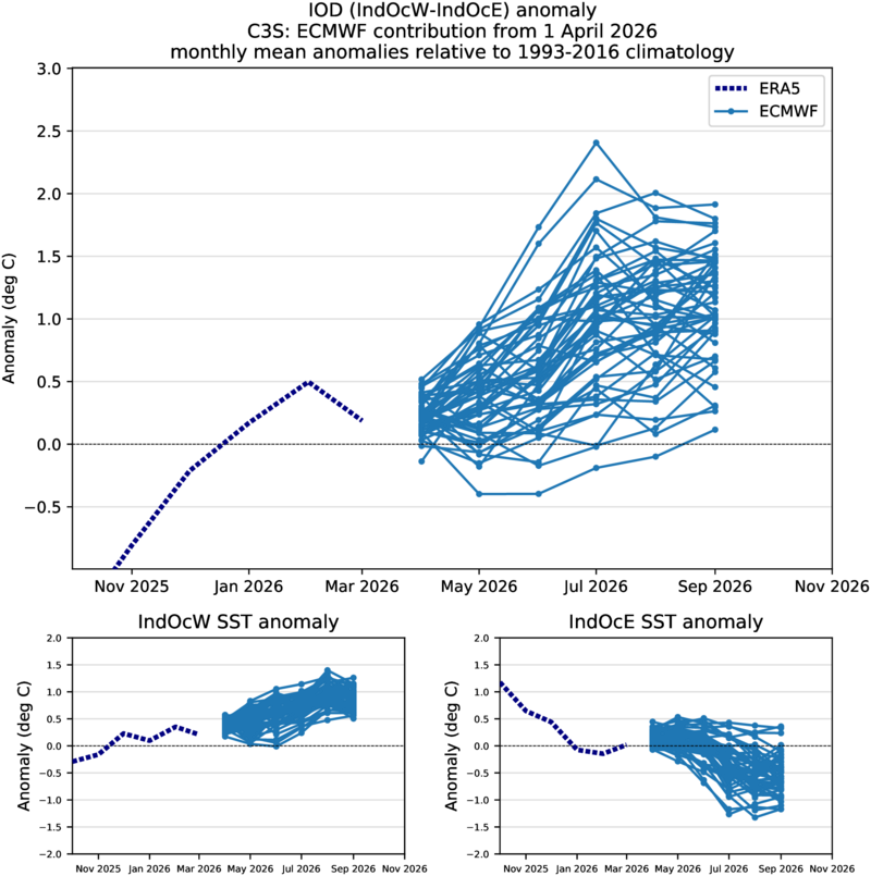
Simultaneously, the Indian Ocean is showing strong positive IOD characteristics: (See the Indian Ocean SST anomalies)
-
IOD Index: Projected to reach +1.5 to +2.0°C in August (strongly positive)
-
Western Pole: Warmer than normal waters in the western Indian Ocean
-
Eastern Pole: Cooler than normal waters near Indonesia and Australia
Why This Combination Changes Everything
The simultaneous occurrence of a positive IOD during Super El Niño creates a unique meteorological situation that reduces the expected impacts of Super El Niño on the Indian monsoon.
Understanding the Counteracting Effects
Typical El Niño Impact on India:
- Suppresses monsoon circulation
- Reduces rainfall by about more than 20% during strong events (historical range)
- Creates high-pressure systems over the Indian Ocean
- Weakens the thermal contrast driving monsoon winds
- Effects are often regionally variable, not uniform across India
Positive IOD Compensating Mechanisms:
- Enhances moisture transport toward India from the warm western Indian Ocean
- Strengthens the monsoon circulation through increased land-sea temperature contrast
- Creates favorable conditions for convective activity over the subcontinent
- Offsets the weakening effect of El Niño on monsoon dynamics
Historical Precedents and Analysis
While Super El Niño events coinciding with strong positive IOD are rare, historical analysis provides some insights:
Case Study: 1997-98 Event
During the 1997-98 Super El Niño—the strongest of the 20th century—the actual monsoon impact was surprisingly modest:
- Actual Impact: Only 9% below normal rainfall nationally
- Key Finding: Despite extreme Pacific temperatures, monsoon suppression was limited
- Regional Variations: Northwestern regions most affected, eastern areas near-normal
- Lesson: Even the strongest El Niño doesn’t guarantee severe widespread drought
Case Study: 2015-16 Reality Check
The 2015-16 Super El Niño provides important perspective:
- Forecasted Impact: Predictions of severe drought based on Pacific temperatures
- Actual Impact: 14% below normal rainfall, no severe drought materialized
- Key Factors: Improved water management, irrigation infrastructure, and soil moisture helped buffer impacts
- Regional Variation: Northwestern India most affected, other regions showed resilience
Case Study: 2006 IOD Dominance
The 2006 season saw a moderate El Niño (+1.2°C) with a strong positive IOD (+1.6°C):
- Result: Above-normal monsoon rainfall (108% of long-period average)
- Mechanism: Positive IOD completely overwhelmed El Niño’s suppressing influence
- Regional Pattern: Enhanced rainfall over central and western India
Regional Implications for 2026 Monsoon
Based on established physical mechanisms of El Niño and IOD interactions, along with historical analogies, regional impacts may vary significantly across India. However, it’s important to note that peer-reviewed research specifically validating state-level forecasts under compound El Niño + positive IOD conditions remains limited.
Expected Regional Patterns (Based on Physical Mechanisms)
Western Coastal Regions: Positive IOD typically enhances moisture transport from the warmer western Indian Ocean, potentially benefiting states like Maharashtra and Gujarat. Historical evidence from strong positive IOD years (such as 2006) suggests these areas often receive favorable monsoon conditions.
Eastern India and Bay of Bengal Region: Positive IOD has historically been associated with enhanced convective activity over the Bay of Bengal, which could support normal to above-normal rainfall across eastern states. This mechanism has been observed in past positive IOD events.
Northern Plains: These regions typically show the strongest response to El Niño suppression. While positive IOD may provide some compensation, the interaction effects are complex and less predictable at the state level.
Southern Peninsula: The Southwest monsoon may benefit from positive IOD influences, though the Northeast monsoon (October-December) faces different dynamics that require separate analysis.
Important Limitations
- Forecast Uncertainty: Regional monsoon forecasting under compound climate events carries significant uncertainty
- Research Gaps: Most studies focus on continental-scale impacts rather than state-level variations
- Local Factors: Topography, land use, and local circulation patterns can override large-scale climate signals
- Temporal Variations: Even if seasonal totals are favorable, the timing and distribution of rainfall may vary considerably
Conclusion
The 2026 Super El Niño event, while formidable in its projected strength, may arrive with a crucial companion: a strong positive Indian Ocean Dipole. This rare combination has historically not been associated with severe drought conditions in India.
However, this optimistic outlook comes with important caveats. Climate forecasting, especially for compound events, carries inherent uncertainties. Continued monitoring of oceanic conditions, regular model updates, and flexible adaptation strategies remain essential.
This event serves as a reminder of the intricate connections within Earth’s climate system and the importance of comprehensive, multi-faceted climate monitoring and forecasting in an era of rapid climate change.
This article is based on the latest climate model forecasts available as of April 2026. Conditions may evolve, and readers are advised to stay updated with official meteorological forecasts from their respective national weather services.