El Niño and the Indian Monsoon — A Tug of War Across Oceans
El Niño suppresses India's monsoon — but not always. This article unpacks the ENSO-monsoon link, regional contrasts, and the Indian Ocean Dipole's counterforce role.

- Dr. Vivek Shilimkar
- 10 min read
The Indian Summer Monsoon Rainfall (ISMR) is not merely a weather pattern. It is the circulatory system of an entire civilisation. Between June and September, the monsoon delivers roughly 80% of India’s annual precipitation — filling reservoirs, recharging aquifers, and determining the fate of Kharif crops that feed over a billion people. The long-period average (LPA) for this June–September window is 868.6 mm, a number that anchors every seasonal forecast and every agricultural planning cycle. When the India Meteorological Department (IMD) classifies a season as “deficient” — defined as rainfall falling below 90% of LPA — the consequences ripple through food prices, rural incomes, and river flows for years.
No external force shapes this outcome more powerfully than El Niño. But the relationship between El Niño and the Indian monsoon is neither simple nor deterministic. Understanding it requires tracking a three-way dynamic: El Niño’s suppressive pressure from the Pacific, the Indian Ocean Dipole’s moderating counterforce, and the monsoon’s own internal variability. Getting that picture right is increasingly a matter of scientific urgency — and human consequence.
What Is El Niño? The Pacific Pulse That Reshapes Asia
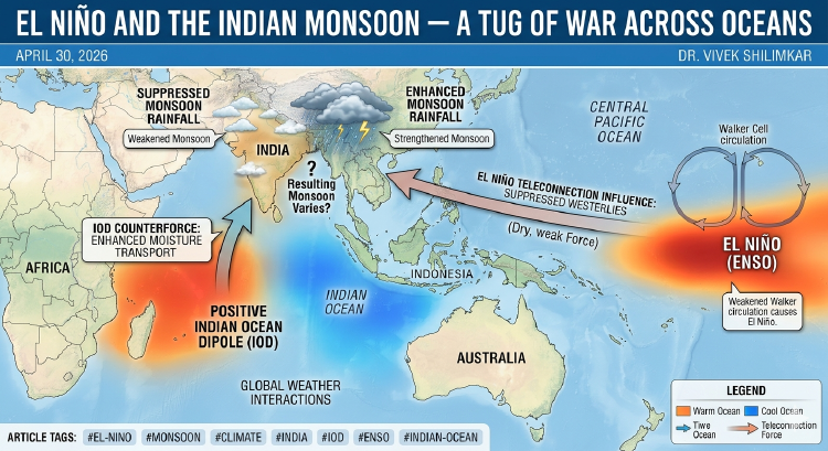
El Niño refers to the anomalous warming of sea-surface temperatures (SSTs) in the central and eastern equatorial Pacific Ocean. Under normal conditions, strong trade winds blow westward across the tropical Pacific, piling up warm water near Australia and Indonesia while drawing cooler water to the surface off the South American coast. The Walker Circulation — the vast atmospheric loop driven by this east-west temperature gradient — keeps this system in balance.
During El Niño, the trade winds weaken. Warm water spreads eastward. The Walker Circulation slackens and, in strong events, partially reverses. The atmospheric consequence for South Asia is anomalous subsidence — a sinking of air over the Indian subcontinent that suppresses convection, weakens the moisture-laden winds flowing off the Arabian Sea, and reduces the organised deep cloudiness that produces the monsoon’s rain.
Researchers track El Niño intensity using the Niño 3.4 index, which monitors SST anomalies in the east-central equatorial Pacific. IMD and the Indian Institute of Tropical Meteorology (IITM) use this index as a primary input into seasonal monsoon forecasts.
The Historical Verdict: El Niño vs. Indian Rains
The statistical record is long enough to be revealing, and complicated enough to demand nuance.
Analysis of strong-to-moderate El Niño events from 1871 to 1978 found that Indian monsoon rainfall was below normal across most of the country in the majority of El Niño years. Looking at the more recent period — 15 moderate and strong El Niño events between 1951 and 2022 — the monsoon was deficient in 8 years and below-normal in 3 more, giving roughly a 73% probability of sub-par rainfall in a moderate-to-strong El Niño year.
But the exceptions are as instructive as the rule. The strongest El Niño of the 20th century, in 1997–98, produced no drought — Indian rainfall that year was above average. By contrast, the relatively weak-to-moderate El Niño of 2002 was one of the driest monsoon seasons on record, with a deficit of approximately 19%. Intensity, it turns out, is not destiny.
The more recent record adds another layer. All four El Niño events since 2000 have adversely impacted Indian rainfall, including the weak 2004 episode that still produced a monsoon 14% below normal. Whether this reflects a genuine strengthening of the ENSO–monsoon link in recent decades, or simply an unfavourable run of coincidences, remains an active research question.
Within the season itself, El Niño acts partly by amplifying “break” monsoon phases — extended dry spells that interrupt the active wet periods. Even in years where some weeks see normal rainfall, prolonged breaks can drag seasonal totals below the deficiency threshold.
Does El Niño Hit All of India Equally?
The answer is clearly no, and the regional pattern matters for policymakers and farmers in different ways.
Research shows that the statistical association between El Niño and deficient rainfall is most significant over subdivisions west of 80°E longitude and north of 12°N latitude — broadly covering northwest India, the Indo-Gangetic Plains, and central India. IITM research led by Dr. Roxy Mathew Koll finds that the El Niño–monsoon relationship has strengthened over north India in recent decades, while it has weakened and become largely non-existent over central India — the “core monsoon zone” — where the dominant driver has shifted to the intensity of the monsoon trough and monsoon depressions.
For south India, the relationship has remained moderately strong and stable throughout the last century, making it a more predictable region in El Niño years.
Perhaps the most counterintuitive finding comes from a 2025 study published in Science, which examined 120 years of rainfall records from 1901 to 2020. The study found a regional split: during El Niño, rainfall became less frequent but more intense in central India and along the southwestern coast, while the southeast and northwest saw reductions in both total rainfall and extreme events. In practice, this means El Niño can simultaneously cause drought conditions in Punjab and Rajasthan while triggering intense, damaging flood events in parts of Maharashtra and Kerala — a forecasting challenge with no easy resolution.
Does a Stronger El Niño Always Mean a Worse Monsoon?
The intuitive assumption — that a bigger El Niño produces a bigger monsoon deficit — does not hold in the historical record.
Analysis of El Niño events from 1950 to 2012 shows no clean linear relationship between El Niño intensity and monsoon deficit. Some of the weakest El Niño episodes have produced severe droughts; some of the strongest have not. What appears to matter more is the timing of El Niño’s development. A summer El Niño, developing during June–September, tends to produce a more significant negative impact — research shows an average rainfall deviation of 22% across the country in summer-developing events, with more than 15% of the Indian region experiencing significant deficits. A spring El Niño, developing earlier in the year, carries a different regional signature.
The type of El Niño also matters. Eastern Pacific (EP) El Niño events — where warming is centred in the far eastern Pacific — tend to have a stronger atmospheric footprint over South Asia than Central Pacific (CP) events, sometimes called El Niño Modoki, where warming is concentrated in the central Pacific. CP events can leave the Walker Circulation partially intact and produce a less coherent suppression signal over India.
The historical anchors make this concrete:
- 1918 (strong El Niño): severe nationwide drought
- 1972 (strong El Niño): one of the worst droughts of the 20th century
- 2002 (weak–moderate El Niño): monsoon deficit of ~19%, the worst in decades
- 2015 (strong El Niño): rainfall at 86% of LPA, a 14% deficit — the second consecutive deficient year after 2014
The 2002–2015 contrast is particularly striking. A strong El Niño in 2015 produced a serious but not catastrophic deficit. A weaker event in 2002 was devastating. The difference, as the next section makes clear, lies in what was happening in the Indian Ocean at the same time.
The Counterforce: The Indian Ocean Dipole
The Indian Ocean Dipole (IOD) is a coupled ocean-atmosphere phenomenon measured by the Dipole Mode Index (DMI), defined as the SST difference between the western equatorial Indian Ocean (roughly 50–70°E, near the Arabian Sea) and the eastern equatorial Indian Ocean (roughly 90–110°E, near Sumatra).
A positive IOD (pIOD) occurs when the western Indian Ocean is warmer than average and the eastern basin is cooler. This configuration enhances moisture transport into the Indian subcontinent, directly counteracting El Niño’s suppressive effect. A negative IOD reverses the gradient and compounds El Niño’s damage.
Research shows that in the presence of a positive IOD, an otherwise suppressed monsoon during an El Niño year can remain close to normal. This moderating influence has become especially prominent since the 1980s, coinciding with the period during which the direct ENSO–monsoon teleconnection began to weaken.
The 1997 vs. 2015 contrast is the sharpest natural experiment we have. Both years featured near-super El Niño conditions in the Pacific and a positive IOD in the Indian Ocean. Yet the outcomes diverged sharply: 1997 produced a near-normal monsoon, while 2015 delivered a 14% deficit. The analysis of these contrasting years points to differences in the spatial configuration of the anomalies and, critically, the strength of southwesterly flow toward the Indian landmass. In 2015, anomalous atmospheric subsidence persisted despite the positive IOD — suggesting the relative magnitudes of the two signals, not just their signs, determined the outcome.
The 2019 season provides the clearest case of pIOD dominance. That year saw the strongest recorded positive IOD event, lasting approximately seven months from May to November. Combined with a moderate El Niño Modoki in the Pacific, the net result was a seasonal rainfall of 110% of LPA — a significantly above-normal monsoon, despite El Niño being present. The IOD did not merely compensate for El Niño; it overwhelmed it.
The structural relationship between the two phenomena adds a further complication: positive IOD events frequently co-occur with El Niño. El Niño’s warming of the eastern Pacific can, through atmospheric teleconnections, drive anomalous cooling of the eastern Indian Ocean — the very configuration that generates a positive IOD. The two phenomena can thus push the monsoon in opposite directions simultaneously, creating the forecasting complexity that makes seasonal prediction so difficult and so consequential.
Is El Niño’s Grip on the Monsoon Weakening?
IITM-led research covering 1901–2018 reveals a non-stationary relationship. The ENSO–ISMR teleconnection strengthened from 1901 to 1940, remained strong through approximately 1980, but has decreased to a moderate level in the 1981–2018 period.
Several mechanisms have been proposed to explain this weakening. Rising background SSTs in the Indian Ocean may be providing a persistent source of moisture that partially offsets El Niño’s suppressive effect. Increased frequency of positive IOD events in recent decades — itself potentially linked to Indian Ocean warming — provides a more regular counterforce. Shifts in the Walker Circulation under anthropogenic warming may also be altering how El Niño’s signal propagates across the tropics.
The IPCC’s projections add an unsettling dimension: global warming is expected to increase the frequency and intensity of extreme El Niño events. If that projection holds, and if the ENSO–monsoon relationship simultaneously continues to weaken, the net effect on Indian rainfall is genuinely uncertain. More frequent strong El Niños could produce more frequent disruptions even if each individual event’s monsoon impact is somewhat reduced. Or the IOD’s moderating role could grow stronger. The honest scientific answer, for now, is that we do not know.
Forecasting in an Uncertain System
What emerges from this body of research is a picture of the Indian monsoon as a system shaped by multiple interacting drivers — not a single lever that El Niño can pull at will. El Niño is the dominant but not deterministic influence. Its effect depends on its strength, timing, type, and above all on whether a positive or negative IOD co-occurs and with what intensity.
Modern seasonal forecasting at IMD and IITM reflects this complexity. Operational long-range forecasts now track ENSO state, IOD evolution, and Indian Ocean SST patterns in combination, rather than relying on any single predictor. The skill of these forecasts has improved significantly over the past two decades, though reliable prediction of monsoon rainfall at the sub-divisional level — the scale that matters most for agricultural planning — remains an active frontier.
The human stakes make this science matter beyond academic interest. Roughly 60% of Indian farmers depend on monsoon rains for Kharif crop productivity. A deficient season cascades into food price inflation, rural distress, and pressure on irrigation infrastructure that can last for years. Accurate El Niño–IOD coupled forecasting is not just a meteorological challenge. It is a socioeconomic imperative — and one that the climate science community, with all the complexity it now navigates, is better equipped to address than ever before.
This article is part of ongoing writing on climate science and its connections to human systems at clustersandclimate.com.